
I find that whilst Google Maps gets me from A to B more efficiently than using a spiral bound mapbook, I lose a lot of enjoyment of the journey from the unnecessary voice overs, and the fact that the route chosen has nothing to do with my preferred sensory experiences as I travel through cities. Ideally I would like a mobile map app that provides help in initially working out a route, has prompts to keep me on track but whose prompts are the mimimum needed so that I don’t get lost but can still engage with my journey as a sensory spatial experience, observing changing scenes of the city similarly to how I could if I was walking along some of my favourite routes through the city.
I think that these improvements would be quite easy to make to maps if they just allowed a small amount of user decision making in setting up the planned route. Here is how the sequence of steps could work:
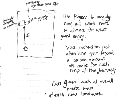
- Starting point and destination are chosen by tapping a finger on each (initiates tactile engagement with the image of the city)
- The app could suggest about 2 route options that derive from data about usual travelling preferences (e.g. taking into account vehicle type, preferences for vegetation, route speed, traffic blockages). These routes can then be altered by pulling routes with your finger.

3. Key landmarks could now be more visually distinctly shown as symbols to allow for easy reference when glancing at the screen. (Alternatively this visual enhancing of the city image could assist the route creation process e.g. by pressing and holding your fingers on the map until visually enhancing information slowly fades in).
4. Voice instructions should only come in to redirect when you have veered more than a certain amount from the planned route (enough to be getting lost).
Suggested reading:
LYNCH, KEVIN. 1960. The Image of the City. MIT Press
GEHL, JAN. 2010. Cities for People. Island Press
